


Adaptation & Resilience Program
What we love about Santa Barbara also makes us more vulnerable to hazards.
Santa Barbara's natural beauty - its beaches, mountains, creeks, and forests - is part of what makes it so special. These same features also make us more exposed to hazards like wildfires, inland and coastal flooding, erosion, and drought.
-
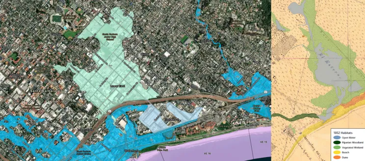 Downtown Flood Zones (Left) are Located on a Former Lagoon (Right)
A large portion of downtown was built on the El Estero Lagoon that extended from the ocean to Anapamu and Milpas Streets. Filled for development in the early 1900s, the area now floods during large rainstorms.
-
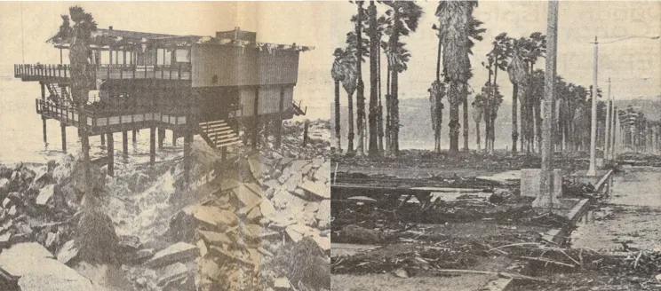 1983 El Nino Storm Damage
Coastal hazards like storm surge and erosion are not new for Santa Barbara. However, climate change combined with more development in flood-prone areas is increasing the severity and frequency of impacts.
-
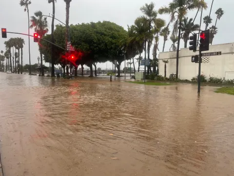
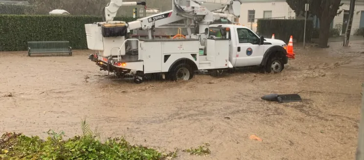 January 2023 Storm Flooding
The warming atmosphere and ocean are resulting in more intense rainstorms. January 2023 would have been considered a 10-year storm in the past, but storms of this magnitude are expected to become twice as likely going forward.
-
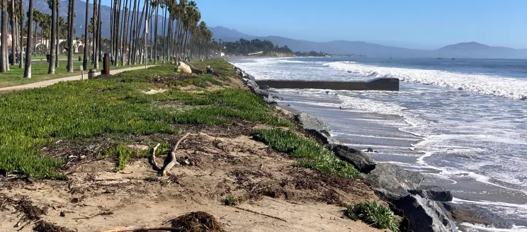 Erosion on East Beach
Shoreline erosion is accelerating due to rising sea levels and stronger storm surges, threatening Santa Barbara’s iconic beaches, beach economy, and waterfront parks and infrastructure. Shifting some waterfront infrastructure inland can give our beaches more room to persist into the future.
-
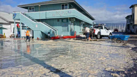
 December 2023 Coastal Storm Surge
Rising sea levels and stronger storm surges are causing more frequent and severe flooding in the Harbor and low-lying areas along the waterfront. In the coming decades, as sea levels rise accelerates, low-lying areas north of Cabrillo Boulevard could also flood during coastal storms.
-
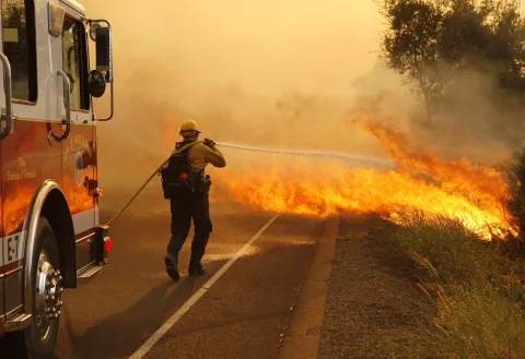
 Smoke from the 2017 Thomas Fire
Wildfire smoke from the 2017 Thomas Fire reduced air quality to dangerous levels. Drier conditions from warmer temperatures and more variable rainfall are fueling more frequent and intense wildfires in Southern California.


How is the City Responding?
Key City Initiatives
Resilient Wastewater System and Water Supply Planning
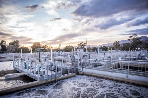
We are building long-term resilience by:
- Implementing a Wastewater and Water System Climate Adaptation Plan that adapts the City's wastewater and water infrastructure to address vulnerabilities from increased flooding due to changes in rainfall patterns, sea level rise, and rising groundwater levels.
- Planning for extended droughts and a diversified water supply portfolio with the Urban Water Management Plan.
Monitoring Changing Conditions
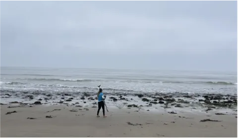
We are tracking coastal changes through the Regional Coastal Adaptation Monitoring Program (RCAMP), which helps us understand how sea level rise, erosion, and flooding are affecting Santa Barbara.
We are also identifying key triggers - like flood frequency and beach width loss - that tell us when it's time to act. This helps us respond early, protect public spaces, and stay ahead of future risks.
Addressing Climate Vulnerabilities in City Planning
We are implementing and building from key foundational plans to improve our community's resilience to current and future climate-related hazards including:
- 2021 Citywide Sea Level Rise Adaptation Plan
- County Climate Vulnerability Plan
- Hazard Mitigation Plan
- Safety Element
- Coastal Land Use Plan
Together, these plans guide how we protect infrastructure, natural areas, and public spaces from climate hazards.
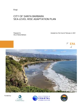
Waterfront Adaptation
We have laid the groundwork with our comprehensive 2021 Citywide Sea Level Rise Adaptation Plan and are planning for the future through the Waterfront Adaptation Plan.
These plans prepare the Santa Barbara waterfront for increased storm surges, erosion, and flooding by providing solutions that preserve and enhance recreation, commerce, beach access, habitat, and critical infrastructure for the near term and future generations.
Airport Adaptation
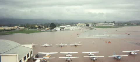
The Santa Barbara Airport (SBA) is advancing its climate resilience efforts through the Airport Adaptation Plan, which builds on the Citywide 2023 Sea Level Rise Adaptation Plan and the 2015 Goleta Slough Area Management Plan.
This forward-looking initiative will address the increasing risks of flooding driven by projected sea level rise and intensified rainfall, helping to safeguard Airport operations, surrounding ecosystems, and community infrastructure.
Stormwater Management Improvements
We are improving how we manage stormwater by:
- Modeling the system to identify needed upgrades.
- Prioritizing flood control projects that also restore habitat and reduce greenhouse gas emissions.
- Encouraging infiltration through the City's Storm Water Management Program (SWMP) promoting rain gardens, permeable paving, and other green infrastructure solutions to improve water quality and reduce runoff that causes flooding.
New and Existing Development Standards

We are making sure new development is ready for future conditions by:
- Implementing FEMA floodplain requirements.
- Updating development standards in low-lying areas to improve flood protection and prepare for future infrastructure needs.
- Developing Creek Buffer Standards to reduce the risk of erosion, flooding, and damage to structures and habitat.
- Applying bluff and coastal hazard setbacks in the Coastal Land Use Plan.
Wildfire Protection Planning
Through our Community Wildfire Protection Plan we are:
- Preparing for wildfires year-round.
- Pursuing vegetation maintenance projects.
- Supporting home hardening.
Regional Collaboration

We know that climate change doesn't stop at City boundaries - so, we're working closely with neighboring communities, regional agencies, and state partners to build resilience together. We are members of regional partnerships, including the Santa Barbara County Regional Climate Collaborative and the Beach Erosion Authority for Clean Oceans and Nourishment (BEACON).
These partnerships help us:
- Align local and regional priorities.
- Share resources and technical expertise.
- Coordinate emergency response and long-term planning.
- Amplify community voices across jurisdictions.